
July 3, 2024
By Jim McCarthy
The removal of four hydroelectric dams on the Klamath River near the Oregon-California state line is nearly complete.
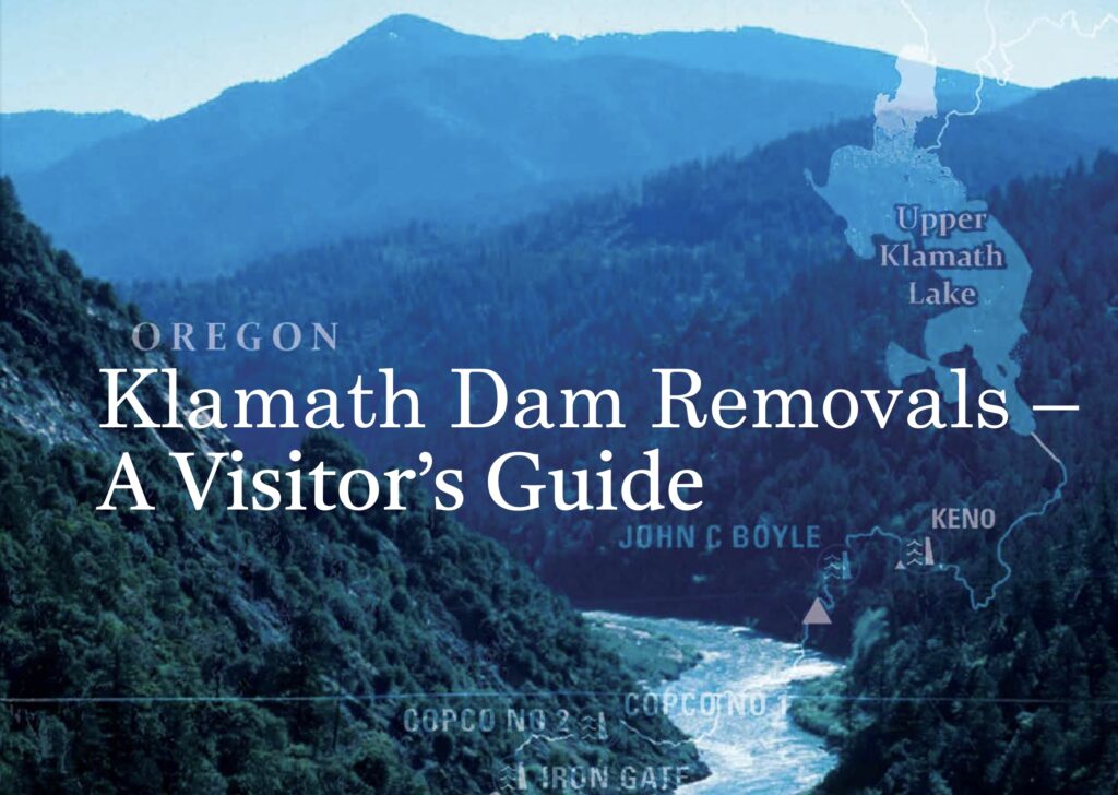
The smallest of the four dams, Copco 2, was removed last summer. The other three, far larger dams were breached this January in preparation for the major structural removal now taking place. The Klamath River mainstem is finally free-flowing from Keno Dam — near the southeast Oregon Cascades community of the same name — to the Pacific Ocean near Redwood National Park. Most importantly, the 350 miles of high elevation aquatic habitat these former dams closed off to salmon, steelhead, and other native migratory fish since 1918 are on the cusp of being reopened to both upstream and downstream fish migration.
Klamath dam removal has generated a great deal of public and media interest, as well as a fair number of questions for WaterWatch’s Southern Oregon staffer about how to best view a river undergoing the largest dam removal in the nation’s history. What follows are recommendations for non-locals wishing to visit the reemerging Klamath River in the coming months.
Please keep in mind cellphone coverage and services are scarce in this relatively remote and rugged area. In addition, the roads nearest the former dams are rough and getting rougher with the continuous coming and going of work crews, heavy equipment, and dump trucks. Some nearby roads and campgrounds may be closed due to the construction. Please travel with companions in a well-maintained vehicle with a spare tire or flat kit, obey all posted signage, and keep an eye out for heavy equipment. We recommend bringing ample water and binoculars, but strongly recommend against attempting to walk on or otherwise enter any areas covered with exposed former reservoir sediments, as these areas may be unstable and/or undergoing restoration.
Visitors to the Klamath River at the former dam complex in this time of profound transformation are sure to experience beautiful, fascinating, and inspiring views of a river and surrounding valley reemerging. As of this spring, the river had cut down through the old reservoir sediments to underlying cobble and bedrock channels. Riffles, rapids, and sweeping bends have emerged in the river, as have grasses, wildflowers, and other vegetation on the river banks. There are standing clusters of formerly submerged riverside trees visible. In places, stone walls and the abutments of an old river bridge are visible.
The easiest route via the smoothest pavement to a former dam site is Route 66/Green Springs Highway, which departs from I-5 at Ashland or Route 97 in Klamath Falls. It would be a good idea to fuel or charge up in either of these towns before heading toward the Klamath River. This road will take you to directly to the J.C. Boyle Dam area. In fact, it crosses the former J.C. Boyle reservoir — now the free-flowing Klamath River.
The dirt and gravel Topsy Grade Road leaves Route 66 on the east side of the river crossing and runs even closer to the old dam. However, this road may be closed due to construction. Topsy Grade could theoretically take you all the way to the community of Copco Lake and the area of the former Copco 1 Dam and reservoir, but this way to Copco 1 is definitely not recommended for travel in either direction.
A safer way to the former Copco 1 and Iron Gate dams is to depart I-5 at Hornbrook just south of the California-Oregon line and take Copco Road toward the Iron Gate Dam site. This heavily potholed but paved road then climbs past this most downstream of the dam sites and continues alongside the former Iron Gate reservoir toward Fall Creek, after which it narrows to single-lane gravel and dirt. The adventurous and well-equipped can continue from here on a single dirt lane past the nearby but not visible Copco 1 Dam site and into view of the former Copco 1 reservoir.
The dirt road returns to pavement near the community of Copco Lake. Visitors may cross the Klamath River at the only bridge in town, then return to the town of Hornbrook and I-5 by turning right onto the paved Ager Beswick Road. This road passes close to the Klamath River for a short distance before proceeding away and out of view of the former dam complex. Turn right onto Ager Beswick Road, then left onto Copco Road a few miles downstream of Iron Gate.
Klamath dam removals present a major opportunity to restore important but dwindling fish runs vital to the region, Native American tribes, and coastal communities. WaterWatch is grateful this long-sought goal for many in the Klamath is within sight. However, dam removal alone cannot restore the Klamath and end the region’s woes. Restoration will require other essential steps, like providing adequate streamflows and lake levels to support abundant salmon and other native fish, improving fish passage at Keno Dam and other dams upstream of the soon-to-be former hydro complex or removing these structures altogether, protecting and restoring depleted groundwater reserves, and reclaiming converted wetlands to recover aquatic habitat and natural water storage while improving water quality.
Thanks to your support, WaterWatch will continue to advocate in public, in the legislature, and in the courts for these essential steps toward the Klamath’s sustainable future.
As many readers know, and as part of our larger, long-standing Klamath Basin campaign, WaterWatch began advocating for the removal of the four lower Klamath dams over two decades ago. For a brief history of our advocacy, see our article Federal Regulator Says Four Lower Klamath Dams May Come Down from the spring 2023 issue of our Instream newsletter, or at WaterWatch.org.
This article originally appeared in the summer 2024 issue of WaterWatch of Oregon’s Instream newsletter.