By Emily Cureton Cook | March 28, 2022 | Oregon Public Broadcasting
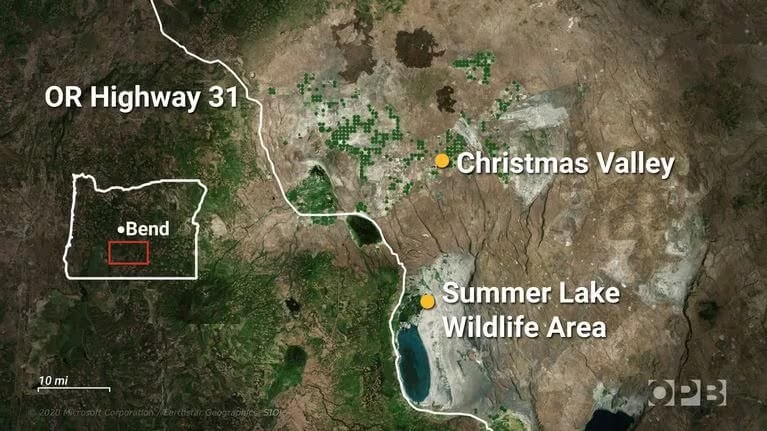
Oregon has protected land at Summer Lake Wildlife Area since 1944. Water is another story. Under current water rights, vital springs could run dry within a generation.
The ground crumbled, kicking dust behind Marty St. Louis as he made his way down an embankment. He carefully pushed aside razor-sharp greasewood branches, moving past towering sagebrush. Then, in just a few steps, the desert transformed.
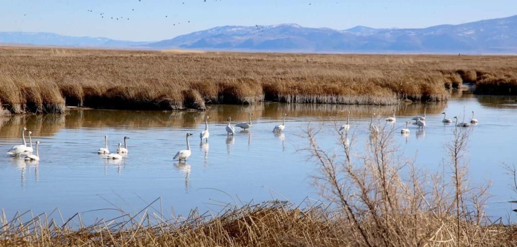
Velvety ferns hugged a lush river bank. Under the water’s clear surface, aquatic plants waved and shone like green hair. Not far from here, springs bubble up from the ground, flowing into the Ana River and powering one of Oregon’s most iconic wetlands at the Summer Lake Wildlife Area.
St. Louis, a biologist, was the wildlife area’s manager for more than 30 years. He retired from the Oregon Department of Fish and Wildlife in 2020, and remains an avid guide to the 19,000-acre spread of state land, where people have documented more than 250 bird species.
“We’re right here in the Pacific flyway,” St. Louis said on a recent tour.
Flyways are the main routes birds use to move north and south across North America. The wetlands around Summer Lake provide an important rest stop in the mostly dry and inhospitable expanse of the continent’s Great Basin.
Scanning the horizon with his binoculars, St. Louis spied more than a dozen species on a February day. Among them, a gaggle of tundra swans who spend their summers in the Arctic, a pair of sandhill cranes and some 15,000 snow geese in a constant state of roaring chatter.
“They’re probably chewing each other out,” St. Louis said of the geese. “They’re a quarrelsome lot.”
Marshes at Summer Lake became Oregon’s first wildlife area in 1944, with priorities to protect bird habitat and public hunting grounds. While the area’s water source begins with gushing freshwater springs, it ends in a reservoir made salty by evaporation. Summer Lake, and Lake Abert to the southeast, are the two surviving remnants of a much larger, ancient water source that once covered this part of Southern Oregon’s Lake County.
Scientists believe Summer Lake has been around for at least 10,000 years. Its main source springs can release water that’s been percolating through rocks for a millennium. This slow-moving water cycle provides a drought-resistant lifeblood in a region with very little annual rain and increasingly less snow. But, current state management of groundwater puts the Ana River springs in danger of disappearing within a generation. Their flow has been in steady decline since wells began pumping water to nearby hay farms.
Environmental advocate and attorney for WaterWatch Lisa Brown said the state agency managing water supplies has stood by for decades, allowing agriculture in the Fort Rock basin’s Christmas Valley to doom a prized public resource.
“It’s alarming that we have a plan in place in Oregon to basically dry up Summer Lake,” Brown said.
The nonprofit WaterWatch of Oregon often challenges decisions by the Oregon Water Resources Department. In 2014, Brown sounded alarms that led to a moratorium on new water rights in Harney County, one of Oregon’s most overdrawn basins. Now, Brown worries that Ana Springs, and by extension Summer Lake, will become the next casualty of a timid state agency that fails to reel in water rights holders.
“It’s really a relic of an old outdated approach,” she said. “This should be a lake that Oregon is proud to have and that we strive to sustain.”
Due to declining groundwater, the state Water Resources Department stopped allowing new irrigation water rights in Lake County’s Fort Rock basin in 1990. Leading up to that freeze, a state scientist studied the area’s aquifers. His report matter-of-factly describes how farming at 1980s levels will likely dry out natural springs feeding Summer Lake, and groundwater flowing to the Upper Deschutes Basin. The scientist estimated total depletion might take decades, or it might take a century.
“That vagueness is for a reason,” said Donn Miller, the hydrogeologist who wrote the state report and retired from the Water Resources Department in 2010.
Miller believes the concept in his report is solid, but a timeline is hard to predict. Human-caused climate change adds another layer of uncertainty.
“That’s a spooky factor,” Miller said of more recent climate change models. “It’s not sounding good.”
Miller’s research predicts that before Ana Springs go dry, desert plants with deep roots will wither and die. He estimated that this will happen at around 50 feet of groundwater decline, a point at which current state regulations say the Water Resources Department might finally step in. The springs would be lost if groundwater declined another 20 feet beyond that.
“There’s no reason to believe the analysis is incorrect or unreliable,” Water Resources Department groundwater manager Justin Iverson said in an email.
So far, the state has tracked a 17-foot drop in groundwater in the basin, with the majority of it, some 13 feet, occurring since the 1990 moratorium on new irrigation water rights.
More than 30 years later, water use by agricultural wells has only increased, with the potential for dramatically more pumping under existing water rights. In Lake County, the regional economy is more reliant than ever on alfalfa hay farming, as the crop’s value soars through export markets to Asia and the Middle East.
A foreseeable conflict over the fate of Summer Lake, which state water managers have long known about and failed to prioritize, will pit people who value Ana Springs against those whose communities depend on farming in the Christmas Valley.
Oregon Water Resources Department deputy director Doug Woodcock acknowledged that wells in the region are lowering the water table. He denied an intentional plan to favor farmers.
“That’s just the nature of groundwater hydrology,” Woodcock said in an interview in March.
State studies of two Eastern Oregon basins — Summer Lake and Malheur County’s Cow Valley — suggest the department has a practice of allowing irrigation pumping to dry up surface water connections where agricultural interests dominate the landscape.
State regulators don’t track how much water Fort Rock basin farmers use. About 99% of the wells in the area aren’t required to measure and report what they take out of the ground.
“We have not been working down in that area because we have more critical areas to evaluate in the state right now,” Woodcock said. “The department does have a charge to manage the area sustainably and as we can get to it, we will.”
The agency said it does plan to eventually track the water usage with remote-sensing technology through funding provided by the Oregon Legislature in 2021, but it’s not clear when those efforts will start.
Exporting Water
While the state has not tracked regional water usage in Christmas Valley, some hay farmers using the water have. Their analysis of electrical power records indicates the region’s farms are pumping out about 20 percent more water than they were in 1990. Under the existing water rights, farmers in the future could legally draw more than double the amount people were taking out when Miller first predicted spring declines.
Dan Jansen is a Christmas Valley hay grower who wants to conserve more water, and avoid a crackdown on water rights.
“If we get cut back here, it’s going to be devastating,” he said. “This will be a ghost town. There will be nothing but blowing sand here if we don’t have the alfalfa crops.”
As president of the Lake County Hay Growers Association, Jansen has been pushing his fellow growers for more discussion of the region’s groundwater declines. He wants farmers to agree there’s a problem, or likely will be, and pursue conservation measures to increase efficiencies. He has spoken out against irrigation happening illegally, either intentionally or more often, he said, because growers misunderstand the limits of their water rights.
Recently, water use monitoring and enforcement by the state water department has been virtually nonexistent in Christmas Valley. Beginning in 2000, the department entered a two-decade span without issuing any notices of violation. In 2020, the local enforcement arm of the agency — known as the watermaster — took stock of the valley, and found about 1,400 acres being irrigated without a water right, and one clear case of illegal use. The department broke its dry spell on enforcement and sent 25 warning letters.
Jansen commended the shift. His goal is to avoid more drastic state interventions, which could diminish legal water rights across more than 50,000 acres.
Farming didn’t exist in the Christmas Valley until the 1970s and 80s, Jansen said. Now, he described a tight-knit community largely made up of multi-generational families.
“It’s really about waking up in the morning and going out, and working your tail off and having something in the barn to show for that,” he said.
The U.S. Department of Agriculture valued Lake County’s hay crops at around $44 million in 2017, the last year for which figures were available. Since then, the sale price of alfalfa has boomed. Jansen estimated that in more recent years, the county’s irrigated farms conservatively translate to around $75 million in annual gross revenue.
The basin’s harsh conditions and temperature extremes are part of what makes the hay so valuable in an international market.
“This is the best climate, probably in the world, for this crop,” Jansen said.
Cold nights slow down the growth of the hay, he explained, which makes it more nutritious as livestock feed. The bales fetch a premium price in many Asian countries, like China, Japan, South Korea and Taiwan.
“Now we’re starting to get a lot of Middle East countries that are buying because they don’t have any water to grow it,” he said. “We’re exporting water in a sense.”
A Thousand Cuts
While some hay farmers are preparing for a future where their livelihoods will be affected by declining groundwater, the reality is already starting to show for the wildlife area.
The state Department of Fish and Wildlife knows Ana Springs are declining, and will likely continue to do so.
“We are accustomed to managing with scarcer water,” the wildlife area’s current manager Jason Journey said in an email.
This means allowing some wetlands to dry out in the spring and summer, whereas in the past they would have had water all year. Journey said the bright side is that the dry periods allow managers to clear or burn invasive vegetation, fine tuning the habitat to appeal to certain bird species.
Former wildlife area manager St. Louis said it’s difficult to judge exactly how migratory birds are reacting to less water, without a widespread geographical study. He worries that refuges like Summer Lake are disappearing all over the world.
“It’s like death by a thousand cuts. And it’s going to take a lot to figure out some solutions to reverse that,” he said.
St. Louis said the conflicts brewing underground in Lake County are a matter of time. Water managers in the state face problems that could become catastrophes in 10, 20 or 50 years — which can seem far off when other parts of Oregon are seeing urgent collapses in the water table.
But when compared to a lake that’s 10,000 years old, the decades until Ana Springs dry up are only a fleeting moment.
This story originally aired on Oregon Public Broadcasting on March, 28, 2022, as part of OPB’s “Race to the Bottom” series, focusing on how Oregon officials’ management of groundwater supplies have fueled crises and inequities, leaving the state ill-prepared to meet the challenges of drought and human-caused climate change.